EPOS GeoJSON
Purpose
The EPOS Platform extends the standard GeoJSON format to support additional features required for enhanced visualization and functionality within the EPOS GUI. These EPOS-specific extensions allow for richer representation of geographic data, enabling capabilities beyond the standard GeoJSON specification without introducing entirely new data formats.
@epos JSON Objects
All new root JSON objects introduced to support EPOS functionality will be accessible via attribute names that start with @epos_. This is to avoid name clashes and false positives parsing the GeoJSON for EPOS specific information. All EPOS specific JSON objects are optional; if any are missing, sensible default behaviour will be followed, ensuring the raw GeoJSON can still be rendered.
{
    "type": "FeatureCollection",
    "@epos_style": {
        ...
    },
    ...
}
Styling: Map Markers and Legends
The EPOS GeoJSON extensions allow for detailed control over the styling and behavior of map markers and the generation of associated legends. This is primarily managed through the @epos_style object.
The @epos_style object can contain a collection of named styles. Each style is an object that defines the appearance and behavior of a marker. The name of the style is used as a key. This allows for multiple different styles to be defined in the same GeoJSON payload.
A feature can then reference one of these styles by setting its @epos_type property to the name of the desired style. If a feature's @epos_type matches a key in the @epos_style object, that style will be applied to the feature.
Multi-Style Example
Here is an example of an @epos_style object with multiple styles defined. The keys for each style are unique identifiers.
style:
" @epos_style": {
  "quakeml:eu.emsc/event/20250813_0000293": {
    "label": "quakeml:eu.emsc/event/20250813_0000293",
    "marker": {
      "character": "A",
      "pin": true
    }
  },
  "quakeml:eu.emsc/event/20250813_0000392": {
    "label": "quakeml:eu.emsc/event/20250813_0000392",
    "marker": {
      "character": "B",
      "pin": true
    }
  }
}
A feature can then use one of these styles by referencing the key in its @epos_type property.
feature:
{
  "geometry": {
    "coordinates": [
      159.679,
      51.5039
    ],
    "type": "Point"
  },
  "properties": {
    ...
    "@epos_type": "quakeml:eu.emsc/event/20250813_0000293",
    ...
  },
  "type": "Feature"
}
In this example, the feature will be styled using the quakeml:eu.emsc/event/20250813_0000293 style definition from the @epos_style object.
Style Attributes
Each @epos_type defined in the @epos_style object defines the following:
| Attribute | Description |
|---|---|
label | If provided, this is used as the text to associate with the map marker in the legend; else the @epos_type is used as the legend text. |
marker (object) | If provided, attributes of this object define the marker for the @epos_style; else a default point marker will be used. |
marker.pin | Defaults to true if absent; if true, the map symbol will be drawn with a pin. |
marker.clustering | Defaults to true if absent; if true, map markers in close proximity to each other will be "clustered". |
marker.anchor | If pin = false, the anchor point for the symbol can be defined using the eight points of the compass (N, NE, E, SE, S, SW, W, NW, C). |
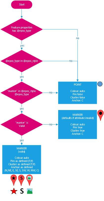
@epos_style is designed for styling map markers on point features only. It does not support custom styling for polygons, lines, or other geometry types; these geometries use default layer-wide styling instead.
Symbols
The EPOS GeoJSON extensions support four distinct types of map markers, configured by setting the appropriate attribute within the marker object of your @epos_style definition. Only one symbol type should be specified per marker.
| Type | Example | pin = false | pin = true |
|---|---|---|---|
marker.href | www.thing.com/thing.png | ||
marker.fontawesome_class | fas fa-star | ||
marker.character | S | ||
marker.raw | iVBORw0KGgo... | The raw image is rendered as-is. | The raw image is rendered inside a pin. |
Image Example
"thing": {
    "label": "This is a thing", //use for legend
    "marker": {
        "href": "www.thing.com/thing.png", //image url type value
        "pin": false, //true|false
        "clustering": false, //true|false
        "anchor": "C" // N|NE|E|SE|S|SW|W|NW|C (default: C) used when pin=false
    }
}
Font Awesome Example
"event": {
    "label": "This is an event", //use for legend
    "marker": {
        "fontawesome_class": "fas fa-star", //fontawesome-class type value
        "pin": false, //true|false
        "clustering": false, //true|false
        "anchor": "C" // N|NE|E|SE|S|SW|W|NW|C (default: C) used when pin=false
    }
},
Character Example
"station": {
    "label": "This is a station", //use for legend
    "marker": {
        "character": "S", //character type value
        "pin": true, //true|false
        "clustering": true //true|false
        //"anchor":"C"  not needed when pin=true
    }
},
Raw Image Example
This example uses a base64 encoded image as the marker. The raw property should contain the raw data of an image, for example a base64 encoded PNG.
"quakeml:eu.emsc/event/20250813_0000293": {
  "label": "quakeml:eu.emsc/event/20250813_0000293",
  "marker": {
    "anchor": "C",
    "clustering": false,
    "pin": false,
    "raw": "iVBORw0KGgoAAAANSUhEUgAA...ADnoNlQAAAFJklEQVR4nOyd..."
  }
}
Symbol Logic
Colour
A note on color, to prevent accidental reuse of the same color by multiple map layers in the EPOS GUI, colors will be automatically assigned.
Legends
Legends are constructed by combining the map marker and label from the corresponding @epos_type within the the @epos_style object.

Legend Logic
Image Overlays
The EPOS GeoJSON extensions provide robust support for image overlays, allowing you to display geo-referenced images directly on the map. This is achieved by adding an @epos_image_overlay object to a GeoJSON feature, establishing a direct link between the feature's properties and the overlay's characteristics.
Example
{
    "type": "Feature",
    "properties": {
        "@epos_type": "overlay",
        ...
    },
    "@epos_image_overlay": {
        "href": "https://sandbox.zenodo.org/2017062703_sd_era_4rlks.unw.png",
        "bbox": [
            -4.5184,
            36.4027,
            -3.2463,
            37.7806
        ],
        "legend": {
            "href": "www.abc.com/legend-image.png"
        }
    },
    "geometry": null //NO GEOMETRY FOR OVERLAY
}
Image Overlay Attributes
Each @epos_image_overlay object defined should have the following:
| Attribute | Description |
|---|---|
| href | The URL to the image to display on the map |
| bbox | The bounding box (rectangular region) in which to place the image, the order is [lat1, lon1, lat2, lon2] |
| legend | A legend object can be include to provide a legend appropriate for the image overlay |
| legend.href | The only property of the legend object currently supported is a image URL to be used as the legend for the overlay |
Image Types
The EPOS GUI supports common image types that are typically rendered by web browsers (e.g., PNG, JPEG, GIF), including GeoTIFF for image overlays.
Geometry
For image overlays, the geometry defined in the GeoJSON feature will be ignored. This is because image overlays require rectangular geographic bounds, which are explicitly defined by the bbox attribute within the @epos_image_overlay object. Therefore, it is recommended to set the feature's geometry to null when using image overlays.
bbox
The spatial reference for the bbox is assumed to match the spatial reference for the containing GeoJSON object(s).
The order of the values is [lat1, lon1, lat2, lon2].
Caution: if the area crosses the antimeridian (often confused with the International Date Line), you must specify corners outside the [-180, 180] degrees longitude range.
Leaflet LatLngBounds Reference
For more details on bounding box definitions, refer to the Leaflet LatLngBounds documentation.
Feature Properties: Controlling Map Popups, Data Visualization, and Links
The EPOS GeoJSON extensions enhance the standard GeoJSON properties object by providing mechanisms for data authors to control how feature metadata is presented in the EPOS GUI. This includes defining content for map popups, specifying columns for data visualization tables, and embedding rich links.
This is achieved by introducing @epos_xxx attributes that reference other true properties of the feature, thereby:
- Preventing duplication of metadata solely for EPOS GUI requirements.
- Maintaining the integrity of true GeoJSON properties for other contexts.
@epos_label_key
The value for the @epos_label_key attribute should be the name of one true attribute of the properties object that is to be used when ever a label, title, tool-tip etc. is needed within the EPOS GUI.
"features": [
    {
        "type": "Feature",
        "properties": {
            ...
            "@epos_label_key": "Title", //used for things like tooltips
            ...
            "Title": "adasdasdd",
            ...
@epos_map_keys
The value for the @epos_map_keys attribute should be the ordered names of one or more true attributes of the properties object that are to be used in the map context within the EPOS GUI, for example to define the properties display in the map popup.
"features": [
    {
        "type": "Feature",
        "properties": {
            ...
            "@epos_map_keys": [ //typically used for map popups
                "Title",
                "Description",
                "Summary",
                "@epos_links"
            ],
           ...
            "Title": "adasdasdd",
            "Description": "Hellenic Seismic Network",
            "Summary": "Properties can contain HTML <img src=\"smiley.gif\">",
            "@epos_links": [...]
@epos_data_keys
The value for the @epos_data_keys attribute should be the ordered names of one or more true attributes of the properties object that are to be used in the data-visualisation context within the EPOS GUI, for example to define the columns to display in the data table.
"features": [
    {
        "type": "Feature",
        "properties": {
            ...
            "@epos_data_keys": [ //typically used for data visualisation columns
                "Title",
                "Elevation",
                "Description"
            ],
            "Title": "my title",
            "Elevation": "122",
            "Description": "Hellenic Seismic Network",
            ...
Default Behaviour
If the relevant @epos_ attribute for the context is missing or empty the EPOS GUI will revert to a default behaviour:
| Context | Missing/Empty | Default Behaviour |
|---|---|---|
| Labelling | @epos_label_key | All (non @epos_) primitive (strings) property names will be searched (case-insensitive) for the following: name, title, label, description in that order. If no property is found then there will be no labelling for that feature. |
| Map | @epos_map_keys | All (non @epos_) primitive (numbers, strings, booleans, primitive-arrays) properties will be used in an arbitrary order, for example to populate the content of a map popup. |
| Data Visualisation | @epos_data_keys | All (non@epos_) primitive (numbers, strings, booleans, primitive-arrays) properties will be used in an arbitrary order, for example to populate the columns of the data visualisation. |
Types of Properties
As mentioned above, in general the only properties that the EPOS GUI will support are those with primitive (numbers, strings, booleans, primitive-arrays) values
Links
@epos_links is a special type of property introduced to support the addition of (hyper)links that require an individual object per link to capture the href, label, type and authenticatedDownload (whether the link should be called with authentication headers set, including the EPOS authentication token)
properties:
"features": [
{
"type": "Feature",
"properties": {
...
"@epos_map_keys": [ //typically used for map popups
    "Title",
    "@epos_links"
],
"@epos_data_keys": [ //typically used for data visualisation columns
    "Title",
    "@epos_links"
],
"Title": "my title",
"@epos_links": [
    {
        "href": "http://volobsis.ipgp.fr/volcano-bullexcep.pdf",
        "label": "Download",
        "type": "application/pdf",
        "authenticatedDownload": true
    },
    {
        "href": "https://sandbox.zenodo.org/20170703.unw.png",
        "label": "Preview",
        "type": "image/x-icon",
        "authenticatedDownload": false
    },
    {
        "href": "https://creativecommons.org/licenses/by-sa/4.0/",
        "label": "License",
        "type": "text/html",
        "authenticatedDownload": false
    }
]
Full Sample
Loading...